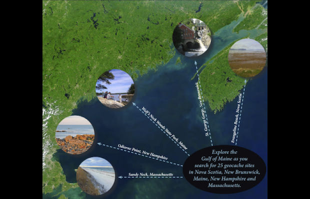
Gulf of Maine Council GeoTour
Many of us Canadians and Americans will make our way around the Gulf of Maine in 2015, taking in Mega events, enjoying summer vacations, visiting friends and family, or just for general travel. And while making our way through Nova Scotia, New Brunswick, Maine, New Hampshire and Massachusetts, we will pass some exciting caches along the Gulf of Maine Geotour route.
So, what is the Geotour?
This Geotour is like a scavenger hunt, but instead of finding traditional treasure you uncover answers to site-specific questions and collect points along the way. At the end of your hunt, once you have collected enough points, you send in your results to the Gulf of Maine Council — and earn a limited edition Gulf of Maine Council Geocoin.
Each state and province participating in the Geotour has five geocaches that highlight important natural, historic, cultural or economic features in the region. To earn the geocoin, you have to accumulate 100 points to complete the tour.
The geocache sites include:
- Nova Scotia
- Cape Forchu Light, Yarmouth
- Annapolis Royal Marsh, Annapolis Royal
- Grand Pré National Historic Site/World Heritage Site, Grand Pré
- Burntcoat Head, Burntcoat
- Joggins Fossil Cliffs, Joggins
- New Brunswick
- Sackville Waterfowl Park, Sackville
- Shepody Bay National Wildlife Area, Harvey
- Fundy National Park, Alma
- Musquash Estuary Marine Protected Area, Musquash
- St. George Gorge, St. George
- Maine
- Cobscook Bay State Park, Dennsyville
- Colonial Pemaquid State Historic Site, Bristol
- Wolfe’s Neck Woods State Parks, Freeport
- Scarborough Marsh, Scarborough
- Wells National Estuarine Research Reserve, Wells
- New Hampshire
- Bunker Creek, Durham
- North Mill Pond, Portsmouth
- Odiorne Point, Rye
- Awcomin Marsh, Rye
- Great Bay Discovery Center
- Massachusetts
- Newbury Marsh, Newbury
- Belle Isle Marsh, East Boston
- Boston Harbor, Boston
- Sandy Neck’s Great Marsh, Barnstable
- Cape Cod Tidal Flats, Brewster
The geotour includes both traditional and earth caches. Some sites require you to hunt for a container with a log book, while others will simply teach you something about the area and have you answer a few questions.
So, if traveling about New England and the Maritimes is on your schedule next year, this Geotour is a great tool to guide you along the way!
For more information on the Geotour, go to the Gulf of Maine Geotour website, or download the details with the Geotour Passport PDF.
I completed the tour over the last couple of months, and it not as hard as I thought it would be. Only had to find 6 sites, but ended up with 9 to get my point required, (You get a bonus if you find one in another province/state). No trip to the states necessary, so no passport required. The sites are a great sampling of the Bay Of Fundy, with earth caches, traditionals, and a couple of “virtuals”. All in all I would encourage any of you coin collectors to have a go at it. And it is a great looking coin.