Satellite Imagery on your Garmin GPS Part II – Mobile Atlas Creator
In Part I of this series on Satellite Imagery, I talked about the use of Garmin Birdseye and how it left a lot to be desired. Since I was quite unhappy with the solution Garmin had presented, I decided to go out into the world wide web and attempt to see what others had done. I knew of software products that could create maps such as OziExplorer but I had also heard that Garmin had released something for creating custom maps for Garmin units. After a post on the Garmin Oregon Wiki page, I was pointed to Mobile Atlas Creator which would turn out to be the best thing I could have found.
 Mobile Atlas Creator (which I’ll refer from here on in as MAC) allows you to create various types of maps using a whole multitude of sources, including both Google Earth and Microsoft Virtual Earth.
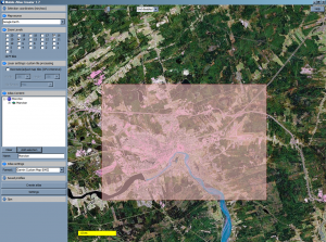
You choose the source for your map information and then simply navigate to where you want to snag the images from. In this screenshot, I zoomed in to Moncton and selected a large area of the city.
You then have the ability to “add” the selection to your new “Atlas”. You can pick as many different locations as you want and simply add them to a single Atlas. It’s a neat way of keeping them collected together.
Once you have all of the areas added to your Atlas, you simply choose the “type” of output you want to create. It has the ability to create Magellan maps, OziExplorer maps, Touratech maps, and last but not least Garmin Custom KMZ overlay maps.
Garmin introduced the ability to create map overlays not that long ago. This functionality allows you to create a map overlay which sits on top of your regular map. There are some limitations but for this exercise, it was extremely easy.
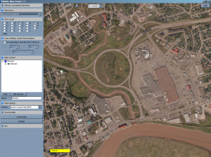
 The image you see here is a zoom in on the same Dieppe traffic circle I mentioned in my Part I article. This one is actually taken from the Microsoft Virtual Earth map which was a little bit clearer than the Google Earth map but not by much.
I can see there from this map, I have a lot more detail in the actual satellite imagery than I did with Birdseye. The key now was to try and get this kind of map and detail onto my Garmin device. It took a little playing but I did get it eventually.
Now, although I don’t entirely understand how it all works, I was able to spend considerable amount of time playing with this software to find out the best way to get the crisp images onto your GPS. It’s not the most user friendly product in the world, but once you get the hand of how it all works, it worked quite well.
I had to choose a zoom level for the map so I chose 14 & 16 which apparently are the most common levels. I also tweaked the software settings to get the images to come out just right. Once I had the settings figured out, I hit “Create Atlas” and it generated the KMZ file I needed to put on my GPS.
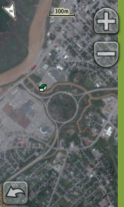
 Getting it onto the GPS is actually the easiest part. You copy the generated KMZ file to the Garmin\Custom Maps folder on your Dakota/Colorado/Oregon GPS and then turn on the GPS unit. The overlay will be automatically enabled and you should be able to start seeing satellite images right away. The screenshot here shows the same traffic circle in Dieppe but this time it’s an actual screenshot from my Oregon GPS. You can even see the geocache icon for a cache nearby.
Mobile Atlas Creator was DEFINTELY better than using Birdseye. The software is small and worked very well, and the fact that you can pull maps from multiple sources (including non-satellite sources) and then easily overlay them made this a FAR better alternative to Birdseye.
My only caution is that it took me awhile to get the right type of quality image on the GPS so that when I zoom in, it still looks good and clear. I did have to do some research on how that all works but once I did, it was simple.
If you want satellite imagery on your GPS, MAC is the way to go!
For those who are interested in seeing a step-by-step tutorial of how to get these satellite images onto your Garmin unit, please feel free to check out this tutorial article.
To watch the video tutorial on Mobile Atlas Creator, click here.
